Tsunami/Phase 1/Lesson3 1
| |||||||||
Tsunami Signage
The large loss of life during the Boxing Day 2004 Indian Ocean Tsunami highlighted to many countries the potential threat posed by tsunami. As a result, many countries have taken steps to increase safety by creating recognisable tsunami signage and erecting it in key places. Check out the signage used in California, and in other places, and see what differences exist, if any. |
| ||||||||
|
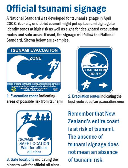
Having recognisable tsunami signage in locations that are at risk of tsunami helps increase public awareness of tsunami and the risks they pose. Because the signs look very similar wherever you go it doesn’t matter if the words are in a different language to your own. In New Zealand, tsunami signage must be consistent with the national standard for tsunami signage. |
| ||||||||
There are five categories of tsunami signs in New Zealand to support public education and the response to tsunamis:
|
| ||||||||
|
The evacuation zone, information board, and evacuation route signs are essential for Survival Agents to achieve effective tsunami education. Evacuation safe locations and previous event signage provide additional means to assist public education. This picture below shows three different categories of tsunami signs you will find throughout coastal parts of New Zealand. Evacuation zone, Evacuation route, and Evacuation Safe Location. |
| ||||||||
|
|
|||||||||
|
If you feel the threat is real, then evacuate to higher ground or inland: don’t wait! |
| ||||||||
|
| |||||||||

