Human earth shapers/ETHS101/Rock Record/Dynamic Geosphere
Contents
Dynamic Geosphere
Earth is a dynamic planet. It is the only rocky planet with active lithosphere plate movement. This means that features, such as craters, so apparent on the Moon and other planets, are erased over time by cycles of mountain building, erosion and plate tectonics.
Plates move at various rates. The Australian plate is moving northwards into Indonesia and the Pacific plate at a rate of about 7 cm a year. This is about twice the speed at which the average healthy person grows fingernails.
Supercontinents
Continents are hard to get rid of once they form. They are the oldest areas on Earth and keep building. While oceanic crust is often pushed down subduction zones, continental crust is too buoyant and instead gets pushed up into mountains. If the continental crust is stretched it can form long rift zones. This is what is happening in the Red Sea area and eastern Africa.
In these rifts, blocks of crust form low areas with high areas either side. If stretching continues, the continental crust can rip apart and new ocean floor can develop. The two masses will become different continents riding along with different plates. In this way, continents have moved around and at times all crushed together into a supercontinent.
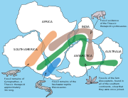
Earth scientists are able to use radiometric dating, fossils and rock groups to help determine when various continental masses were together. Alfred Wegener was the first to suggest this could happen in 1912 based on the similarity of rock groups and fossils across several continents (see panel below).
Continental drift theory
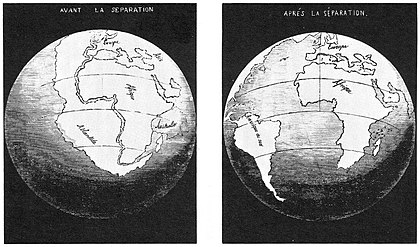
Alfred Wegener noticed that the fossil flora and fauna and their hosting strata matched across parts of Africa, South America, Antarctica, Australia and India. He also noticed excellent matches with the distribution of glacial deposits. The jig-saw like edges of the continents also suggested to Wegener that they once were all together and were split apart. Wegener reconstructed Pangea and his theory was called continental drift. It was published in English in 1924 and met with resistance from the geological community, who believed that continents were fixed. The main criticism against Wegener and his theory was that there was no mechanism that would allow such movement of continents.
It was only in the 1960s and 1970s with the advent of plate tectonic theory that a mechanism to move continents was realised. Alfred Wegener who died in 1930 never lived to know that his theory ultimately gained widespread support.
Plate Reconstructions
Earth scientists suggest that there have been seven supercontinents throughout Earth's geological history, although several of these are contentious. The older the supercontinent, the more sparse is the evidence and data. Very good data is available from dating of the seafloor for the last 200 million years. At that time all Earth's continental masses were together in the last supercontinent called Pangea.
Earthbyte Group at the University of Sydney have been meticulously reconstructing plate motions back through time. Here is a great video of snapshots through time since the break up of the Pangea, over the 200 million years.


