File:Isabel 2003-09-14 1755Z (gallery).jpg
From WikiEducator

Size of this preview: 461 × 599 pixels. Other resolutions: 461 × 600 pixels | 6,000 × 7,800 pixels.
Original file (6,000 × 7,800 pixels, file size: 7.27 MB, MIME type: image/jpeg)
Summary
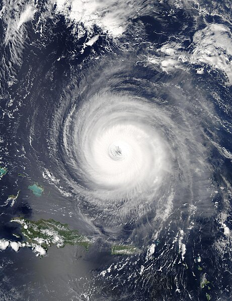
| Description | The MODIS instrument onboard NASA's Aqua satellite captured this true-color image of Hurricane Isabel on September 14, 2003 at 17:55 UTC. In this image Isabel is located about 400 miles north of Puerto Rico and is packing maximum sustained winds near 155 mph. | |||||
| Date | ||||||
| Source | http://visibleearth.nasa.gov/view_rec.php?id=5863 | |||||
| Author | Jacques Descloitres, MODIS Rapid Response Team, NASA/GSFC | |||||
| Permission (Reusing this file) |
|
|||||
| Other versions | Image:Hurricane isabel2 2003.jpg |

.jpg)
| Camera location | | View this and other nearby images on: OpenStreetMap |
|---|
.jpg¶ms=024.000000_N_-066.000000_E_globe:Earth_type:camera__&language=en)
File history
Click on a date/time to view the file as it appeared at that time.
| Date/Time | Thumbnail | Dimensions | User | Comment | |
|---|---|---|---|---|---|
| current | 07:03, 10 November 2006 | | 6,000 × 7,800 (7.27 MB) | Good kitty | == Summary == {{Information |Description=The MODIS instrument onboard NASA's Aqua satellite captured this true-color image of Hurricane Isabel on September 14, 2003 at 17:55 UTC. In this image Isabel is located about 400 miles north of Puerto Rico and is |
File usage
There are no pages that link to this file.
.jpg)
.jpg)
.jpg&action=edit&redlink=1)
.jpg)
.jpg&action=info)