File:AgriOriginsMap.png
From WikiEducator
No higher resolution available.
AgriOriginsMap.png (492 × 217 pixels, file size: 50 KB, MIME type: image/png)
Summary
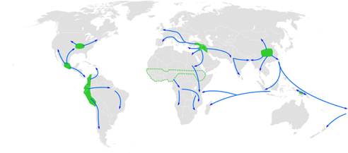
| Description | Centres of origin of agriculture and its spread in prehistory: eastern USA (4000-3000 BP), Central Mexico (5000-4000 BP), Northern South America (5000-4000 BP), sub-Saharan Africa (5000-4000 BP, exact location unknown), the Fertile Crescent (11000 BP), the Yangtze and Yellow River basins (9000 BP) and the New Guinea Highlands (9000-6000 BP). |
|---|---|
| Source | Created by Joe Roe on 29 Nov 2010. Licensed under CC-BY-SA 3.0 Unported. Reproduced without alteration. |
| Date | 2019-11-21 09:14:50 |
| Author | Created by Joe Roe on 29 Nov 2010. Licensed under CC-BY-SA 3.0 Unported. Reproduced without alteration. |
| Permission | See below. |
Licensing
| Licensed under the Creative Commons Attribution-Share Alike 3.0 Unported license, allowing you the freedom to reuse provided proper attribution is maintained and the requirement to distribute any modifications under the same, similar, or compatible terms. |
File history
Click on a date/time to view the file as it appeared at that time.
| Date/Time | Thumbnail | Dimensions | User | Comment | |
|---|---|---|---|---|---|
| current | 10:15, 21 November 2019 | | 492 × 217 (50 KB) | Nsmithies (Talk | contribs) | User created page with UploadWizard |
- You cannot overwrite this file.
File usage
The following page links to this file: