File:Uetliberg LCD.jpg
From WikiEducator

Size of this preview: 800 × 505 pixels. Other resolution: 5,472 × 3,456 pixels.
Original file (5,472 × 3,456 pixels, file size: 3.16 MB, MIME type: image/jpeg)
Summary
| Description |
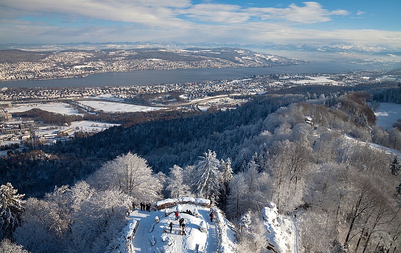
English: View from the top of the telecommunications tower at Uetliberg, Zurich, Switzerland. On the foreground: the observation deck at Uto Kulm, Uetliberg. On center: Lake Zurich and the "Golden Mile" of Zurich. Background, right: the alps of canton Glarus.
Español: Vista desde lo alto de la torre de comunicaciones en Uetliberg, Zúrich, Suiza. En primer plano: la plataforma de observación frente al hotel Uto Kulm. En el centro: el lago de Zúrich y la "Milla Dorada" de la ciudad. En el fondo, derecha: los alpes del cantón Glarus.
Français : Vue depuis le sommet de la tour de télécommunications de l'Uetliberg, sur la commune de Zurich, en Suisse. Au premier plan : la terrasse panoramique d'Uto Kulm. Au centre, le Lac de Zurich et le "Golden Mile" de Zurich. En arrière plan, à droite : les Alpes du canton de Glaris.
|
| Date | 18 December 2010 (according to Exif data) |
| Source | Own work |
| Author | Murdockcrc |
| Other versions |

| Camera location | | View this and other nearby images on: OpenStreetMap |
|---|
Licensing
I, the copyright holder of this work, hereby publish it under the following license:
This file is licensed under the Creative Commons Attribution 3.0 Unported license.
- You are free:
- to share – to copy, distribute and transmit the work
- to remix – to adapt the work
- Under the following conditions:
- attribution – You must give appropriate credit, provide a link to the license, and indicate if changes were made. You may do so in any reasonable manner, but not in any way that suggests the licensor endorses you or your use.
| Annotations | This image is annotated: View the annotations at Commons |
Assessment
|
This image has been assessed using the Quality image guidelines and is considered a Quality image.
|
This image was selected as picture of the day on Wikimedia Commons for 8 May 2011. It was captioned as follows: English: View from the top of the telecommunications tower at Uetliberg, Zurich, Switzerland. Other languages:
English: View from the top of the telecommunications tower at Uetliberg, Zurich, Switzerland. Español: Vista desde la cúspide las torres de telecomunicaciones de Uetliberg, Zúrich, Suiza. Polski: Widok z szczytu wieży telekomunikacyjnej w Uetliberg, Zurich, Szwajcaria. Svenska: Utsikt från toppen av telekommunikationstornet i Uetliberg, Zurich, Schweiz. Tiếng Việt: Cảnh quan nhìn từ điểm cao nhất của tháp viễn thông ở Uetliberg, Zurich, Thụy Sĩ. 한국어: 스위스 취리히의 위에틀리베르크 산 송신탑 위에서 바라본 풍경. 日本語: スイス・チューリヒのユトリベルクに建つ電波塔の頂上からの眺望 |
File history
Click on a date/time to view the file as it appeared at that time.
| Date/Time | Thumbnail | Dimensions | User | Comment | |
|---|---|---|---|---|---|
| current | 07:34, 20 December 2010 | | 5,472 × 3,456 (3.16 MB) | Murdockcrc | {{Information |Description={{en|1=View from the top of the telecommunications tower at Uetliberg, Zurich, Switzerland. On the foreground: the observation deck at Uto Kulm, Uetliberg. On center: Lake Zurich and the "Golden Mile" of Zurich. Background, righ |
File usage
The following page links to this file: