File:San Francisco STS058-083-023.jpg

Summary
Fonte
Earth.Jonhson Space Center.National Aeronautic and Space Administration.government/Space Shuttle Earth Observations Photography/Earth From Space/low resolution.San Francisco from space
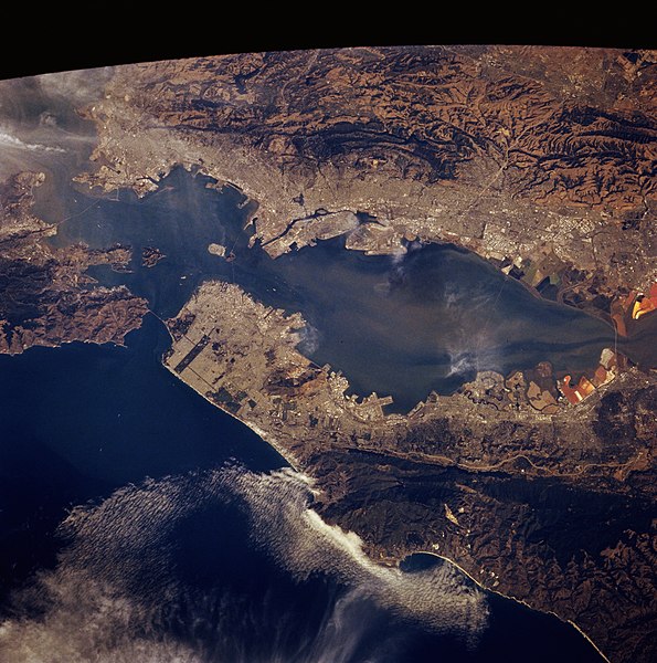
View from Space Shuttle Columbia, mission STS-058, October 20, 1993
San Francisco Bay Area, October 1993
This photograph features the rugged, low mountains and hilly terrain that surround San Pablo Bay and San Francisco Bay, a highly prone earthquake region of coastal California. Apparent are the lighter, reflective urban areas and the darker, low lying, swampy area traversed by a number of sloughs north of Grizzly Bay. The greens and reds immediately northeast of San Pablo Bay have the same characteristics as the salt ponds at the southern end of San Francisco Bay. The higher sediment content in the bays produces higher reflectivity than the deep blue Pacific Ocean. Several landmarks are visible: Golden Gate Bridge, Golden Gate Park, Alcatraz Island, Treasure Island and San Francisco International Airport.
Technical data
- Mission: STS058 (Columbia)
Roll - Frame: 83 - 23 Geographical Name: USA-CALIFORNIA Features: SAN FRANCISCO, PART. FR. Center Lat x Lon: 37.5N x 122.5W Film Exposure: N N=Normal exposure Percentage of Cloud Cover-CLDP: 10 Camera: HB Camera Tilt: 20 LO=Low Oblique, HO=High Oblique, NV=Near Vertical Camera Focal Length: 250
- Nadir to Photo Center Direction: E
The direction from the nadir to the center point, N=North, S=South, E=East, W=West
Stereo?: N Y=Yes there is an adjacent picture of the same area, N=No there isn't
- Orbit Number: 37
- Date: 19931020 YYYYMMDD
- Time: 211555 GMT HHMMSS
- Nadir Lat: 37.2N
Latitude of suborbital point of spacecraft
- Nadir Lon: 123.4W
Longitude of suborbital point of spacecraft
- Sun Azimuth: 205 Clockwise angle in degrees from north to the sun measured at the nadir point
- Space Craft Altitude: 156 nautical miles
- Sun Elevation: 39 Angle in degrees between the horizon and the sun, measured at the nadir point
Landscape
- Land Views: MOUNTAIN, FAULT, HILLS
- coast: SANTA CRUX, MONTEREY, BIG SUR
- valley: CARMEL, SALINAS ,
- islands: ALCATRAZ ISLAND, TREASURE ISLAND
- Water Views: BAY, SEDIMENT
- Atmosphere Views:
- Man Made Views: URBAN AREA, BERKELEY'S UNIVERSITY CAMPUS, SILICON VALLEY
- City Views: SAN FRANCISCO, OAKLAND
- Airport views: SAN FRANCISCO INTERNATIONAL
- Bridge views: GOLDEN GATE, BAY BRIDGE
Content Provider
Kamlesh P. Lulla Ph.D. Chief, Earth Sciences Branch Responsible NASA Official: Ed Wilson Curator: Jaime Powell Last Update: 06/17/2002
This image or video was catalogued by one of the centers of the United States National Aeronautics and Space Administration (NASA) under Photo ID: STS058-083-023. This tag does not indicate the copyright status of the attached work. A normal copyright tag is still required. See Commons:Licensing. Other languages:
|
Licensing
| This file is in the public domain in the United States because it was solely created by NASA. NASA copyright policy states that "NASA material is not protected by copyright unless noted". (See Template:PD-USGov, NASA copyright policy page or JPL Image Use Policy.) | ||
 |
Warnings:
|
File history
Click on a date/time to view the file as it appeared at that time.
| Date/Time | Thumbnail | Dimensions | User | Comment | |
|---|---|---|---|---|---|
| current | 18:17, 1 September 2005 | | 3,872 × 3,904 (11 MB) | Roger469 | San Francisco Bay Area from space |
File usage
The following page links to this file: