File:Ogallala changes 1980-1995.svg
From WikiEducator

Size of this preview: 455 × 599 pixels.
Original file (SVG file, nominally 761 × 1,002 pixels, file size: 1.74 MB)
Summary
| Description |
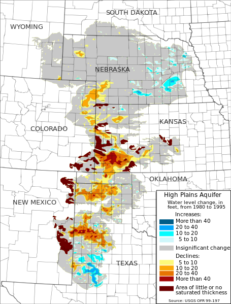
English: Map of water-level changes in the High Plains/Ogallala Aquifer in parts of Colorado, Kansas, Nebraska, New Mexico, Oklahoma, South Dakota, Texas, and Wyoming, 1980 to 1995. Created from public domain data produced by the USGS and made available in Open-File Report 99-197[1][2]. Authors: Fischer, Brian C.; McGuire, Virginia L. |
| Date | |
| Source | Own work |
| Author | Kbh3rd |
| Other versions | File:Ogallala changes in feet 1980-1995 USGS.gif |
Licensing
I, the copyright holder of this work, hereby publish it under the following licenses:
This file is licensed under the Creative Commons Attribution-Share Alike 3.0 Unported license.
- You are free:
- to share – to copy, distribute and transmit the work
- to remix – to adapt the work
- Under the following conditions:
- attribution – You must give appropriate credit, provide a link to the license, and indicate if changes were made. You may do so in any reasonable manner, but not in any way that suggests the licensor endorses you or your use.
- share alike – If you remix, transform, or build upon the material, you must distribute your contributions under the same or compatible license as the original.

|
Permission is granted to copy, distribute and/or modify this document under the terms of the GNU Free Documentation License, Version 1.2 or any later version published by the Free Software Foundation; with no Invariant Sections, no Front-Cover Texts, and no Back-Cover Texts. A copy of the license is included in the section entitled GNU Free Documentation License. |
You may select the license of your choice.
File history
Click on a date/time to view the file as it appeared at that time.
| Date/Time | Thumbnail | Dimensions | User | Comment | |
|---|---|---|---|---|---|
| current | 05:58, 1 March 2009 | | 761 × 1,002 (1.74 MB) | Kbh3rd | {{Information |Description={{en|1=en|1=Map of water-level changes in the High Plains/Ogallala Aquifer in parts of Colorado, Kansas, Nebraska, New Mexico, Oklahoma, South Dakota, Texas, and Wyoming, 1980 to 1995. Created from [[:en:public domain|publ |
File usage
The following page links to this file: