File:NASA and NOAA Announce Ozone Hole is a Double Record Breaker.png
From WikiEducator

Size of this preview: 600 × 600 pixels. Other resolution: 716 × 716 pixels.
Original file (716 × 716 pixels, file size: 411 KB, MIME type: image/png)
Summary
| Description |
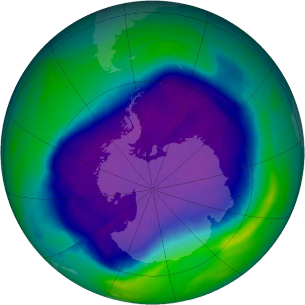
English: From September 21-30, 2006 the average area of the ozone hole was the largest ever observed, at 10.6 million square miles (27.5 million square kilometres). This image, from September 24, the Antarctic ozone hole was equal to the record single-day largest area of 11.4 million square miles (29.5 million square kilometres), reached on Sept. 9, 2000. Satellite instruments monitor the ozone layer, and we use their data to create the images that depict the amount of ozone. The blue and purple colors are where there is the least ozone, and the greens, yellows, and reds are where there is more ozone. |
| Date | |
| Source | http://www.nasa.gov/vision/earth/lookingatearth/ozone_record.html |
| Author | NASA |
Licensing
| This file is in the public domain in the United States because it was solely created by NASA. NASA copyright policy states that "NASA material is not protected by copyright unless noted". (See Template:PD-USGov, NASA copyright policy page or JPL Image Use Policy.) | ||
 |
Warnings:
|
File history
Click on a date/time to view the file as it appeared at that time.
| Date/Time | Thumbnail | Dimensions | User | Comment | |
|---|---|---|---|---|---|
| current | 14:40, 18 February 2012 | | 716 × 716 (411 KB) | Ras67 | JPEG artifacts mitigated and background removed |
File usage
The following page links to this file: