File:Middelgrunden wind farm 2009-07-01 edit filtered.jpg
From WikiEducator
Size of this preview: 800 × 582 pixels. Other resolution: 2,920 × 2,126 pixels.
Original file (2,920 × 2,126 pixels, file size: 893 KB, MIME type: image/jpeg)
Summary
| Description |
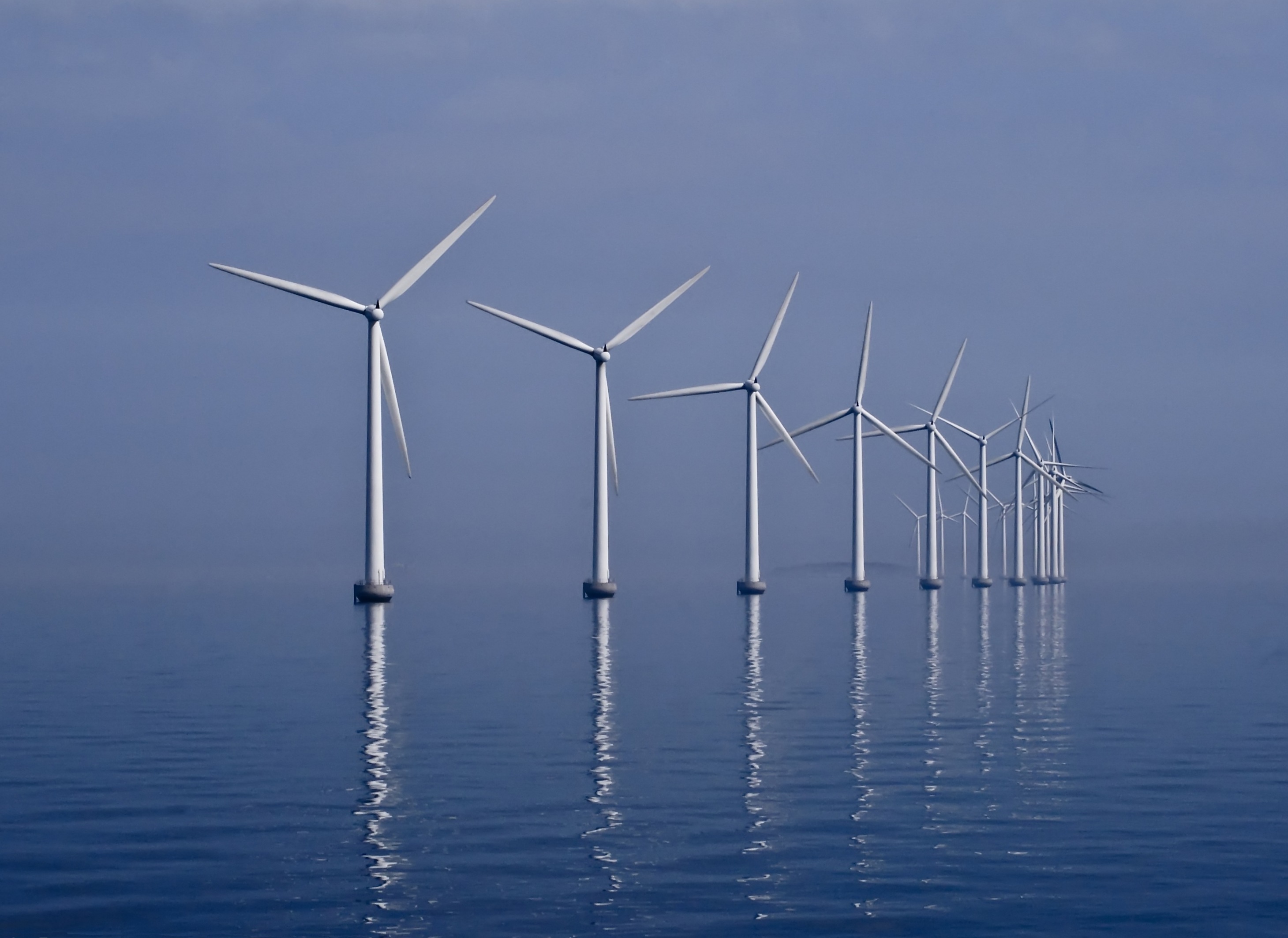
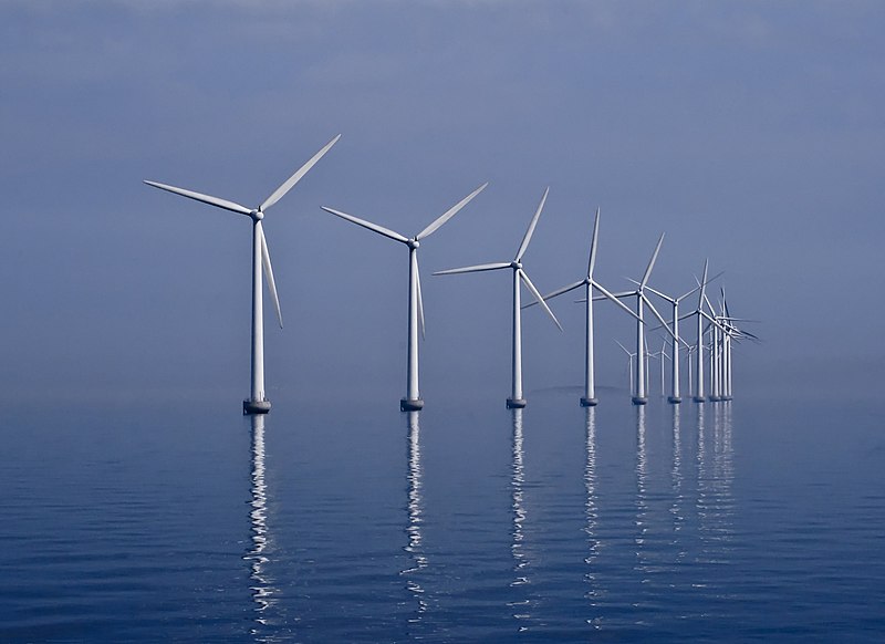
Français : Le champs d'éoliennes offshore de Middelgrunden, dans l'Øresund. L'écartement entre deux éoliennes est de 180 m. Cette photo est exceptionnelle car il est rare de voir une mer d'huile dans le détroit, qui est venté, d'où la présence d'éoliennes.
Suomi: Middlegrunden merituulivoimalapuisto Öresundissa, noin 3.5 km Tanskan pääkaupungin Kööpenhaminan ulkopuolella.
Tiếng Việt: Bãi tuốc bin gió Middelgrunden ngoài eo biển Øresund, Đan Mạch. Bãi tuốc bin gió này được xây dựng năm 2000 và vận hành từ năm 2001, với 20 tuốc bin gió với tổng công suất 40 MW, cung cấp khoảng 4% điện năng cho thành phố Copenhagen. |
| Date | |
| Source | Own work |
| Author |
English: Photo by Kim Hansen. Postprocessing (crop, rotation, color adjustment, dust spot removal and noise reduction) by Richard Bartz and Kim Hansen. |
| Other versions |
|

| Camera location | | View this and other nearby images on: OpenStreetMap |
|---|
| This is a retouched picture, which means that it has been digitally altered from its original version. Modifications: Dust spots removed, colors adjusted by Richard Bartz. Further dust removal in GIMP followed by noise reduction in Noiseware, slight rotation and crop in GIMP by Slaunger..
|
Assessment
This image has been assessed using the Quality image guidelines and is considered a Quality image.
|
This image was selected as picture of the day on Wikimedia Commons for 17 August 2010. It was captioned as follows: English: Middelgrunden offshore wind farm (40 MW) in the Øresund, 3.5 km outside Copenhagen, Denmark. Other languages:
Alemannisch: De Middelgrunden Offshore-Windpark mit ere Leistig vu 40 MW z Øresund, Dänemark. English: Middelgrunden offshore wind farm (40 MW) in the Øresund, 3.5 km outside Copenhagen, Denmark. Français : Le champs d'éoliennes offshore de Middelgrunden, dans l'Øresund. L'écartement entre deux éoliennes est de 180 m. Cette photo est exceptionnelle car il est rare de voir une mer d'huile dans le détroit, qui est venté, d'où la présence d'éoliennes. Македонски: Ветерниот парк Миделгрунден (40 MW) гледан од Ересунд Українська: Офшорна вітрова електростанція Міддельгрюнден в протоці Ересунн поблизу Копенгагена. На момент здачі в експлуатацію в 2000 р. це була найбільша електростанція такого типу в світі — 20 турбін загальною потужністю 40 Мвт. |
This image was selected as picture of the day on Vietnamese Wikipedia.
|
|

 |
This picture was selected in August 2010 for picture of the month at the Portal Denmark at German Wikipedia. |
Licensing
I, the copyright holder of this work, hereby publish it under the following licenses:
This file is licensed under the Creative Commons Attribution-Share Alike 3.0 Unported license.
- You are free:
- to share – to copy, distribute and transmit the work
- to remix – to adapt the work
- Under the following conditions:
- attribution – You must give appropriate credit, provide a link to the license, and indicate if changes were made. You may do so in any reasonable manner, but not in any way that suggests the licensor endorses you or your use.
- share alike – If you remix, transform, or build upon the material, you must distribute your contributions under the same or compatible license as the original.

|
Permission is granted to copy, distribute and/or modify this document under the terms of the GNU Free Documentation License, Version 1.2 or any later version published by the Free Software Foundation; with no Invariant Sections, no Front-Cover Texts, and no Back-Cover Texts. A copy of the license is included in the section entitled GNU Free Documentation License. |
You may select the license of your choice.
| Annotations | This image is annotated: View the annotations at Commons |


File history
Click on a date/time to view the file as it appeared at that time.
| Date/Time | Thumbnail | Dimensions | User | Comment | |
|---|---|---|---|---|---|
| current | 08:22, 17 August 2014 | | 2,920 × 2,126 (893 KB) | Slaunger | Cloned in a few pixels of missing sea in the lower left corner |
File usage
The following page links to this file: