File:Map Europe alliances 1914-en.svg
From WikiEducator

Size of this preview: 800 × 473 pixels.
Original file (SVG file, nominally 1,002 × 593 pixels, file size: 97 KB)
| Description |
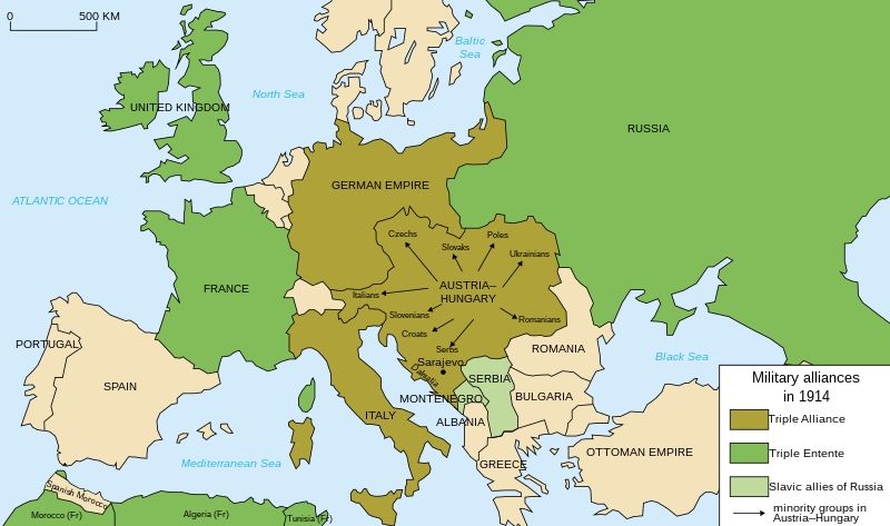
Deutsch: Karte von Militärbündnisse in Europa in 1914, (Englisch) English: Map of military alliances of Europe in 1914. (English) Français : Carte des alliances militaires en Europe en 1914. (Anglais) Русский: Схема военных альянсов в Европе в 1914 г. (англ.) |
| Date |
|
| Source | Translated in English from French SVG Map_Europe_alliances_1914-fr.svg |
| Author |
|
| Other versions |
Derivative works of this file: Map Europe alliances 1914-he.svg
[] .gif)
|


W3C-validity not checked.

|
This SVG file contains embedded text that can be translated into your language, using any capable SVG editor, text editor or the SVG Translate tool. For more information see: About translating SVG files. |
| This is a retouched picture, which means that it has been digitally altered from its original version. Modifications: English translation. The original can be viewed here: Map Europe alliances 1914-fr.svg:
|
I, the copyright holder of this work, hereby publish it under the following license:
This file is licensed under the Creative Commons Attribution-Share Alike 2.5 Generic, 2.0 Generic and 1.0 Generic license.
- You are free:
- to share – to copy, distribute and transmit the work
- to remix – to adapt the work
- Under the following conditions:
- attribution – You must give appropriate credit, provide a link to the license, and indicate if changes were made. You may do so in any reasonable manner, but not in any way that suggests the licensor endorses you or your use.
- share alike – If you remix, transform, or build upon the material, you must distribute your contributions under the same or compatible license as the original.
Original upload log
This image is a derivative work of the following images:
- File:Map_Europe_alliances_1914-fr.svg licensed with Cc-by-sa-2.5,2.0,1.0, Cc-by-sa-2.5,2.0,1.0/en
- 2007-02-26T23:36:35Z Bibi Saint-Pol 998x593 (100171 Bytes) {{Information |Description= {{fr|Carte des alliances militaires en Europe en 1914.}} |Source=Création personnelle(version renommée de [[:Image:Les rivalités en Europe en 1914.svg]]) |Date=2006-10-31 |Author=[[User:Histori
Uploaded with derivativeFX
File history
Click on a date/time to view the file as it appeared at that time.
| Date/Time | Thumbnail | Dimensions | User | Comment | |
|---|---|---|---|---|---|
| current | 08:59, 5 April 2021 | | 1,002 × 593 (97 KB) | Andrewtips | File uploaded using svgtranslate tool (https://svgtranslate.toolforge.org/). Added translation for zh-hant. |
File usage
The following page links to this file: