Co-operative Republic of Guyana
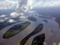
Land of Many Waters
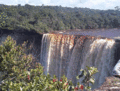
The Majestic Kaieteur Falls
-
FACTS ABOUT GUYANA 
Guyana (pronounced /ɡaɪˈænə/ or /ɡiːˈɑːnə/), officially the Co-operative Republic of Guyana and previously known as British Guiana, is the only country of the Commonwealth of Nations on the mainland of South America. It is bordered to the east by Suriname, to the south and southwest by Brazil and to the west by Venezuela. It is the fourth-smallest country on the mainland of South America (after Suriname, French Guiana, and Uruguay). It is one of the four non-Spanish-speaking territories on the continent, along with the countries of Brazil (Portuguese), Suriname (Dutch) and the French overseas region of French Guiana (French). Culturally, Guyana associates primarily with the English-speaking Caribbean countries such as Jamaica, or Trinidad and Tobago.
Guyana is South America’s only English speaking country. Some Amerindian communities also speak their indigenous language. Creole, which is a pidgin English, is also widely spoken. Guyana lies on the north-east corner of the South American continent between latitudes 1° and 9° N and longitude 56° and 62° W. Mount Roraima 2,810 m. Forms the border with Guyana, Brazil and Venezuela. Georgetown –2m at high tide. This necessitates an elaborate system of drainage canals and sluice gates to drain water at low tide. The country has four distinctive geographical zones: the coastal belt, the forested area, the savannah zone and the sandy zone. Over 80% of the land mass is still covered in pristine forest, and only 2.5% is cultivated. The most valuable mineral deposits are bauxite, gold and diamonds. Western border with Venezuela. South Western and Southern border with Brazil. Eastern border with Suriname. Mean shade temperature is 27°C. Mean maximum is 31°C. Mean minimum is 24°C. The heat is greatly tempered by cooling breezes from the sea. There are two wet seasons in the north of the country, from May to June, and from December to January. The south and the Rupununi region receive one wet season from May to July. All wet seasons may extend into months either side. Rainfall averages 2,300 mm a year in Georgetown. In Georgetown it is predominately 110 volts, though some areas also have 220 volts. In the interior power is by generator only and is 110 volts. The unit is the Guyanese dollar. There are notes for $20, $100, $500, and $1,000. Coins are for $1, $5 and $10. Guyana means “Land of many waters” and the country is full of rivers. These form an important water highway system for traveling in remote areas where there are no roads. The Essequibo River is the world’s 3rd widest river after the Amazon (Brazil) and the Orinoco (Venezuela). It is 21 miles wide at the mouth. Other major rivers are the Demerara and Berbice.
|
|
|
|
Public Holidays
Public Holidays in Guyana
| Public Holiday
|
Date Celebrated
|
| New Years Day
|
1 January
|
| Mashramani Celebration
|
23 February
|
| Phagwah Day
|
When the moon is sighted
|
| Labour Day
|
1 May
|
| Indian Arrival Day
|
5 May
|
| Independence Day
|
26 May
|
| Caricom Day
|
First Monday in July
|
| Emancipation Day
|
First Monday in August
|
| Deepavali Day
|
When the moon is sighted
|
| Christmas Day
|
25 December
|
| Boxing Day
|
26 December
|
A table in a table

|

|
|
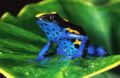
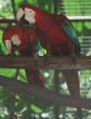
Scenes of Guyana
|
|
| Hindu and Muslim festivals follow a lunar calendar and dates of holiday are announced a week or two prior to the day |
Eid el Fitr, end of Ramadan |
Deepavali, usually November
|
Upcoming Holidays & Events in Guyana
- April 2, 2010 - Good Friday
- April 5, 2010 - Easter Monday
- May 1, 2010 - Labour Day
- May 5, 2010 - Indian Arrival Day
- May 26, 2010 - Independence Day
- July 5, 2010 - Caricom Day
- August 1, 2010 - Emancipation Day
|
|
Guyanese Quotes
Do sah nah like sah
|
|