File:Mound.png
From WikiEducator
No higher resolution available.
Mound.png (213 × 138 pixels, file size: 75 KB, MIME type: image/png)
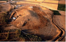
An aerial view of the East Mound at Çatalhöyük, looking towards the north. This photograph was taken from a balloon flying above the mound. The original Mellaart excavation (called the South area) can be seen in the left of the picture. The North area, opened in 1995, including the white shelter of the BACH area, lies at the top of the picture. The guardhouse and the archaeologists' compound is in the top left corner of the picture, including the road leading west to the town of Cumra and east to the village of Küçükköy. In this picture you cannot see the wire fence that surrounds the East Mound.
File history
Click on a date/time to view the file as it appeared at that time.
| Date/Time | Thumbnail | Dimensions | User | Comment | |
|---|---|---|---|---|---|
| current | 08:41, 16 October 2007 | | 213 × 138 (75 KB) | Okapi (Talk | contribs) | An aerial view of the East Mound at Çatalhöyük, looking towards the north. This photograph was taken from a balloon flying above the mound. The original Mellaart excavation (called the South area) can be seen in the left of the picture. The North area, |
- You cannot overwrite this file.
File usage
The following 3 pages link to this file: