File:Grjótagjá caves in summer 2009 (2).jpg
From WikiEducator

Size of this preview: 800 × 533 pixels. Other resolution: 3,777 × 2,518 pixels.
Original file (3,777 × 2,518 pixels, file size: 2.32 MB, MIME type: image/jpeg)
Summary
| Description |
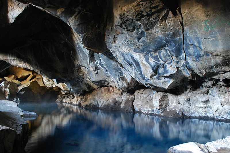
Čeština: Jeskyně Grjótagjá poblíž jezera Mývatn, Island.
English: Grjótagjá caves near Mývatn lake, Iceland.
Français : Grotte et source de Grjótagjá près du lac Mývatn, en Islande. |
| Date | |
| Source | Own work |
| Author | Chmee2 |
| Camera location | | View this and other nearby images on: OpenStreetMap |
|---|
|

.jpg)
.jpg¶ms=065.630222_N_-016.879592_E_globe:Earth_type:camera_region:IS_heading:112.50&language=en)
.jpg)
This image was selected as picture of the day on Wikimedia Commons for 7 November 2010. It was captioned as follows: Other languages:
Íslenska: Hellirinn Grjótagjá, nærri Mývatni, á Íslandi Magyar: A Grjótagjá barlang a Mývatn tó közelében (Izland) Nederlands: Grjótagjágrotten nabij het Noord-IJslandse meer Mývatn Português: Cavernas de Grjótagjá, Islândia. Македонски: Пештерите Грјотаѓа близу езерото Миватн, Исланд 中文: 冰岛米湖边上的格尔约塔焦岩洞 العربية : صورة شاملة للقمر ألتقطت خلال رحلة (أبوللو 17) المحطة الأولى شرق. |
This image has been assessed using the Quality image guidelines and is considered a Quality image.
|
Licensing
I, the copyright holder of this work, hereby publish it under the following licenses:

|
Permission is granted to copy, distribute and/or modify this document under the terms of the GNU Free Documentation License, Version 1.2 or any later version published by the Free Software Foundation; with no Invariant Sections, no Front-Cover Texts, and no Back-Cover Texts. A copy of the license is included in the section entitled GNU Free Documentation License. |
This file is licensed under the Creative Commons Attribution 3.0 Unported license.
- You are free:
- to share – to copy, distribute and transmit the work
- to remix – to adapt the work
- Under the following conditions:
- attribution – You must give appropriate credit, provide a link to the license, and indicate if changes were made. You may do so in any reasonable manner, but not in any way that suggests the licensor endorses you or your use.
You may select the license of your choice.
File history
Click on a date/time to view the file as it appeared at that time.
| Date/Time | Thumbnail | Dimensions | User | Comment | |
|---|---|---|---|---|---|
| current | 10:26, 30 August 2010 | | 3,777 × 2,518 (2.32 MB) | Chmee2 | better crop |
File usage
The following page links to this file:
.jpg)
.jpg)
.jpg&action=edit&redlink=1)
.jpg)
.jpg&action=info)